 RU
RU  EN
EN  CN
CN  ES
ES 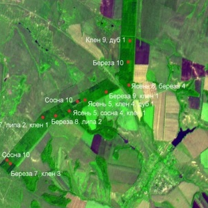
Samara University scholars have created a unique method of monitoring of natural ecosystems and urban environment. It combines large possibilities of space survey with the precision of field studies and allows to follow the changes of bioecological condition of territories as well as to find out any new sites of troubles there.
Accumulated by the scholars of Samara University Department of Ecology, Botany and Nature Protection perennial experience in research and estimation of influence of human impact on vegetation cover and soil became the scientific base of this method. For instance, they developed a database of heavy metals in soils which contains information obtained almost in 1000 concrete spots on the territory of whole Samara region and takes into account the content of about 10000 identifications and combinations of elements in wild (100 species) and cultivated (13 species) plants.
Specialists in Geoinformatics compared data of earth ecological monitoring with space photos of the territories and suggested an information technology for analysis of Earth remote sensing (ERS) data for estimation of soil and vegetation cover condition with sufficient reliability. There is no need to order space survey of the territory being investigated, it is sufficient to use photos with resolution of 1,5 m taken by any spacecraft.
“The main advantage of algorithms being a part of this new information technology is the high speed of computer analysis of space photos. They, for example, make unnecessary a very labour-intensive operation of preliminary clearing of information ERS from hindrances and distortions,” Head of Department of Geoinformatics and Information Security Vladislav Sergeev claims. “Such enhance of calculation productivity allows to crank out bioecological monitoring”.
All information is constantly being actualised via earth system of testing grounds (TG) situated in different parts of Samara region.
“Further development of earth infrastructure of TG for getting a complex of data of field and desktop study will allow forming a large information base for subsequent verification of space photos and enhancement of image identification efficiency. This work opens possibilities of finding additional symptoms of ecological trouble of territories, study of tendencies of perennial changes of soil and vegetation cover with the use of series of space images. All these practical and significant directions can be realised, but require support to the data of ERS by the results of earth study of ecosystems of all types,” Head of Department of Ecology, Botany and Nature Protection of Samara University Ludmila Kavelenova says.
Till now this approach is tested only on some territories of Samara region, but its research and practical significance is not limited by this region. As the leaders of the above mentioned teams of authors - Professors Sergeeva and Kavelenova - explained the methodology developed by them is interesting for other subjects of the RF as well. Data of ERS are open for public and to use them for a bioecological monitoring it is enough to apply regional attachment of developed in Samara University algorithms of automated interpretation of space photos.
In the plans of university specialists on the processing of ERS and Geoinformatics is creation of publicly used Internet service and mobile application with the help of which a wide range of users will be able to get quick and true estimation of biological and ecological condition of the territories in question themselves. Such service will surely be highly demanded by projectors, builders, tourists and other categories of nature resources users.
For reference
The study of influence of different factors on the conditions of ecosystems and urban environment is a traditional work direction of Samara University biologists. Several years ago practically one method of territory study was a ground survey which with high costs on its execution (especially on the plots with difficult access) did not allow to carry survey simultaneously on all plots.
The use for ecological monitoring methods of ERS not only made easier receiving and gathering of information about dynamics of nature systems on the big territory of earth surface, but has raised the precision and exactness of conclusions made on the basis of computer analysis of these data. As a result the possibility of exact finding of earth plots with troubled condition of soil and vegetation cover is proved.